MAPPING URBAN AGRICULTURE IN ROME
Farming the Ethernal City
Eng. Flavio Lupia
Italian Institute for Agricultural Economics (INEA), Rome (ITALY)
Urban agriculture (UA) has been acknowledged for several positive effects such as access to fresh food, human activities moderation, agro-biodiversity and social and cultural relationships.
In the city of Rome due to social and economical trends this kind of activities are spreading, but so far very few attempts has been addressed to inventorying the UA areas (e.g. community gardens, residential gardens, school gardens, illegal vegetable gardens, urban farms, etc.) through Earth Observations techniques. Some mapping experiences have been carried out but all lack of a well established methodology to be applied for a complete inventory.
Urban agriculture (UA) has been credited for numerous positive effects in cities, such as access to fresh food, agro-biodiversity and as a contributor to improved social and cultural relationships. Like many other regions, urban agricultural activities are spreading in the city of Rome, but few attempts have been made to inventory the UA areas (e.g. community gardens, residential gardens, school gardens, informal vegetable gardens, urban farms, etc.) Some mapping attempts have been carried out, but to date all have lacked a well-established methodology for generating a complete inventory.
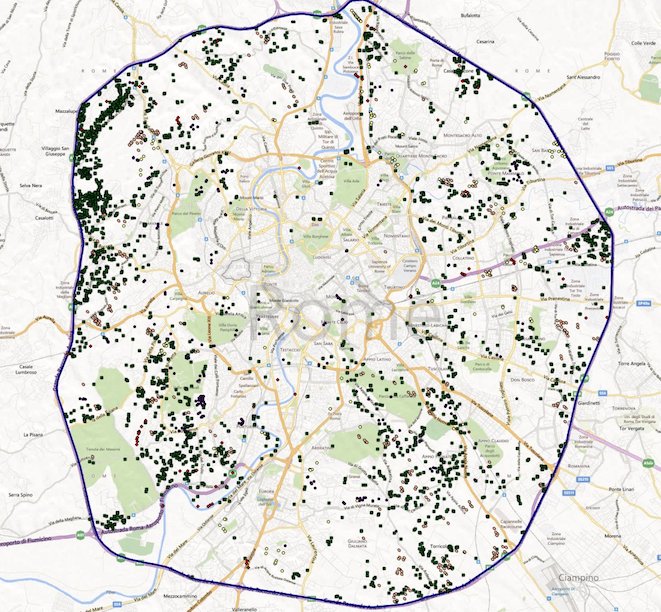
Researchers from the National Institute of Agricultural Economics (INEA) have recently developed a methodology for mapping cultivated parcels of land in the city supported by photointerpretation, harnessing the features of web-mapping services such as Google Earth, Google Maps and Microsoft Bing Maps. Google Earth has been used as basic tool for visual interpretation and polygon digitalization, while other services have been used for their additional features to support the cultivated plots detection (for example, the oblique view of Microsoft Bing Maps).
In addition, all the ancillary data available in the area has been integrated with the web-mapping services to improve the UA sites detection, offering the opportunity to define both the land cover and, in some cases, the land use. The assessment accuracy of the geodatabase is based both on a physical field check and a “virtual field check” realized with the analysis of Google Street View images. The digital approach enables a result in cost and time required to catalog a huge metropolitan area

